
COASTAL RESILIENCE SOLUTIONS FOR DOWNTOWN boston


Stoss, along with Kleinfelder, Arcadis, Woods Hole Group, and ONE Architecture & Urbanism developed a master plan addressing coastal resilience strategies for downtown Boston. Taking recommendations from the 2016 Climate Ready Boston report, the team led public engagement, strategic development and detailed design efforts, culminating in recommendations for an implementation roadmap that sets up timelines and priorities for projects—with the understanding that a coordinated effort across the district is required for a well-conceived public realm that both protects people and allows access to the water.
The process involved stakeholders including private property owners, city staff, utility providers, non-profit organizations and community groups. The civic engagement strategy was multi-pronged and featured open houses, focus groups and multiple one-on-one meetings and interviews. Due to the city scale and the varied ownership along the waterfront, the project was complex and ultimately provided a menu of options that could be implemented by both individual landowners and the City.
The team divided the city into 3 distinct sections; West End/North End, North End Waterfront, and Downtown/Wharf District. Each were evaluated and 3 distinct approaches emerged for each section and were outlined in the final report. Along the coast, recommendations were made to 1) elevate the existing edge and/or 2) build into the water to create natural barriers. A toolkit provides strategic guides and concepts for individual property owners to implement protections on their land. Alternately, 3) a fall-back measure outlines elevating the city-owned roadway to protect inland assets. Lastly, recommendations for marine transportation planning were addressed to assist in city-wide access during the construction of coastal protection strategies.
read the full report
Timeline
2019-2020
Status
Completed
Size
250 acres
client
City of Boston
location
Boston, MA
TEAM
Stoss
Kleinelder
Arcadis
ONE Architecture and Urbanism
Woods Hole Group

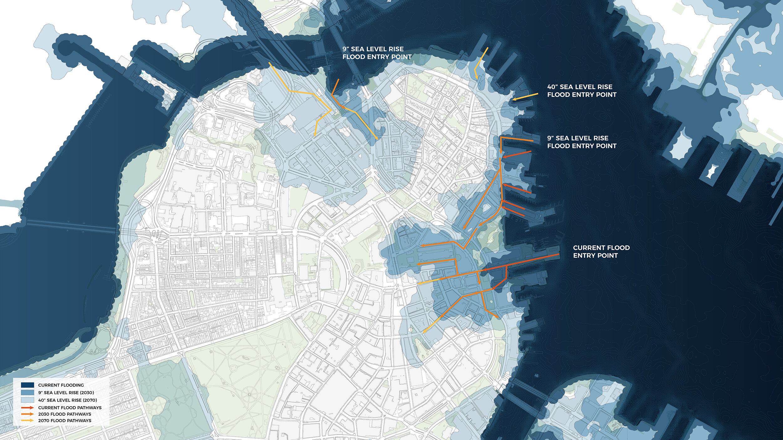
The above map shows strategies at the water’s edge utilizing both City-owned and privately owned land as flood protection.
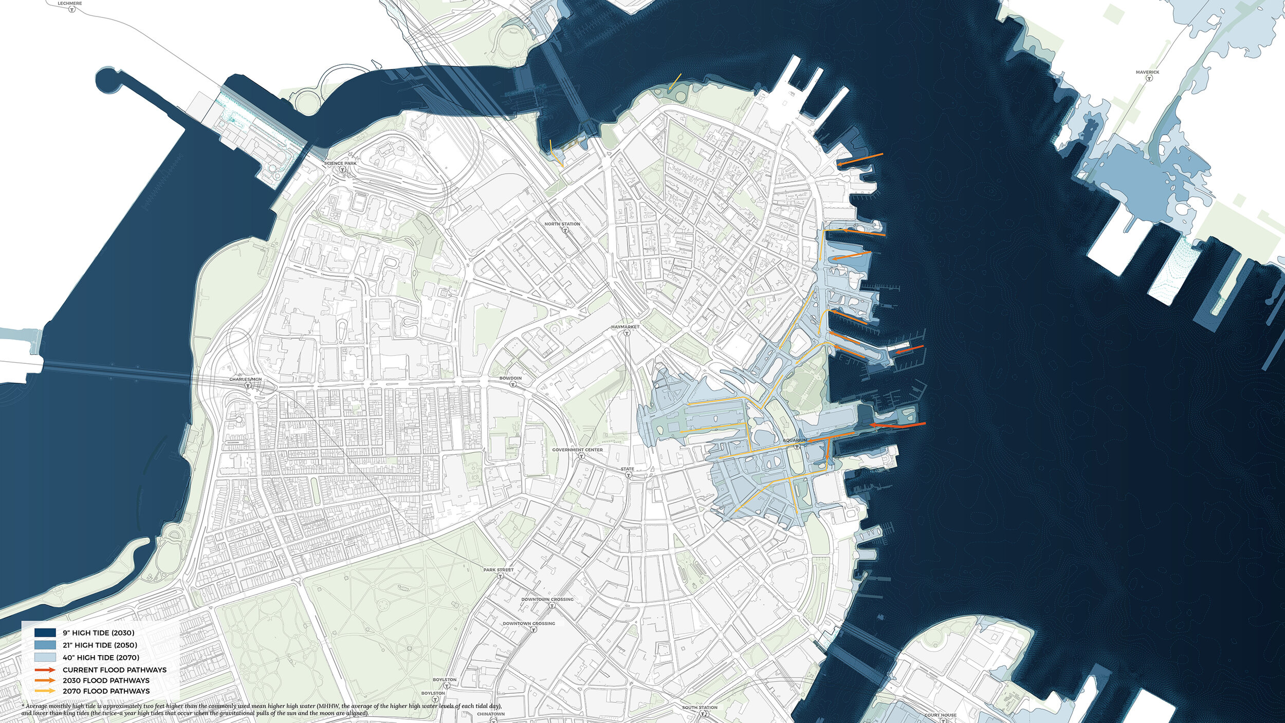
The above map shows strategies on public land utilize the City-owned right-of-way along Commercial Street and Atlantic Avenues as flood protection.
Collaboration
The stakeholder engagement process was dedicated to setting up a collaborative dialogue between neighbors about their assets. The team heard that the majority of stakeholders preferred strategies integrated at the water’s edge rather than one completed within the right of way alone. To achieve this preferred solution and protect the neighborhood from storm surge and sea level rise, continued collaboration between property owners is essential. Building strong partnerships will create multiple opportunities for better protection, improved access, increased property value and commercial activity. In the creation of district-scale plans and sub-district level implementation, the continuity of the system, and its reliability, is dependent on the nodes of collaboration between adjacent properties, between City and State agencies (in particular at the jurisdictional edges where policy and oversight overlap), and between all owners, regulators, utility owners, and operators.
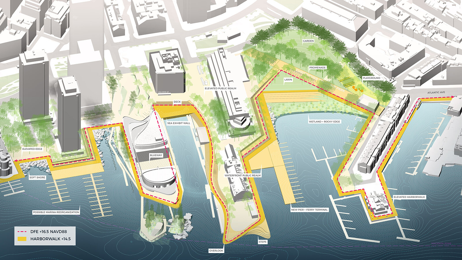
The Downtown Waterfront sub-district plan option showing a dock for marine transit at the historic site of T-Wharf.

At Lovejoy Wharf, there is an opportunity to expand the waterfront and add wetlands and living shoreline. In addition to expanding the harborwalk and connecting to new elevations recently implemented in Langone and Puopolo Parks.
“The current condition of the waterfront is mostly hard-edged, defined by historic stone seawalls and bulkheads that are sometimes protected by riprap. Access to the waterfront and active marina uses are accessed through wooden boardwalks and other pile-supported structures over water. In some places the distance between buildings and the edge of the existing bulkhead is minimal to non-existent; some buildings even overhang the water. Each of these conditions require specific responses and pose unique challenges and opportunities to implement resilience measures. A toolkit of resilience measures is presented here and can be used as a guide for future design decisions. The design variations in this toolkit are intended to work together and to
be combined into an integrated solution to provide comprehensive, district scale protection.”

Resilience Toolkits The report includes a resilience toolkit intended to provide guidance and inspiration for design approaches that may be utilized based on existing conditions. Regardless of the approach chosen for implementation, each will be required to meet the established Design Flood Elevation (DFE) for that district. Final designs will be required to consider physical access as well as a visual and emotional connection to the water.